
Archive Record
Images
Metadata
Object Name |
Map |
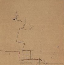
Title |
Street Rwy Map - Waco, Texas - 1891 |
Date |
1891 |
Scope & Content |
1891 Waco Street Railway Map handdrawn in blue ink by Johnnie J. Myers, with street railway lines color coded. This map identifies railway lines, streets, geographic areas (e.g., Brazos River, Huaco Heights) and key buildings (e.g., Cotton Palace, Baylor University, Methodist Home and City Hall). Color coded Street Railway lines are drawn as follows: * Citizen's Rwy. Co. - single track (black), double track (red) * Waco Rapid Transit Company (steam dummy line) - green Railroads depicted in the map include: * Cotton Belt Railroad * Missouri Kansas and Texas Railroad * St Louis and San Francisco Railway |
Search Terms |
Baylor University Brazos River Cotton Belt Railroad Cotton Palace Huaco Heights Huaco Heights Line Icon-Other TER Maps Map Missouri Kansas and Texas Railroad St Louis and San Francisco Railway Waco Carbarn Waco City Hall |
Collection |
Johnnie J. Myers Collection |
Catalog Number |
CP.2006.CL.1-146 |