
Archive Record
Images
Metadata
Object Name |
Map |
Title |
Hand-drawn Texas Electric Railway Denison Division Map 17 |
Event |
Writing the Book Texas Electric Railway |
Date |
ca 1964 |
Scope & Content |
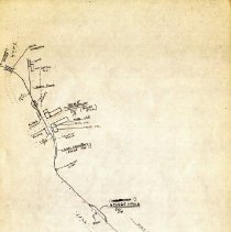
Hand-drawn Texas Electric Railway Denison Division map. Map 17 shows a section of Texas Electric Railway track in Howe, between North Howe Stop and Bowen Siding. Other notable features are Highway US 75, the Houston & Texas Central Railroad (H&TC), Howe [Passenger] Station, Howe Transformer Station [substation], George Siding, Ferguson Stop, and Moore Stop. The unidentified street on the north side of the Passenger Station is currently East Haning Street. The unidentified street on the south side of the Transformer Station is East Davis Street. Highway 5 (N Denny Street) sits just to the west of the area where the Howe Passenger and Transformer stations were located. Created by Johnnie J. Myers and Walter Donaldson, while riding in the rear of a Texas Electric Railway car on the Denison and Waco lines. The number of the map is indicated by a circled number in the bottom right corner. This detailed map was later redrawn by Steve Scalzo from the Central Electric Railfans Association (CERA) for Johnnie J. Myers' book, Texas Electric Railway. This section can be seen on Map 1, detail 6 and 7. |
Associated People |
Donalson, Walter P., Jr. Myers, Johnnie J. |
Search Terms |
Bowen Siding Dallas-Denison Division East Davis Street - Howe East Haning Street - Howe Ferguson Stop George Siding Highway 5 Highway US 75 Houston and Texas Central Railroad Howe Howe Station Howe Substation Icon-Denison Division Maps Map Map 1 Map 1 Detail 6 Map 1 Detail 7 Moore Stop North Denny Street - Howe North Howe Stop |
Collection |
Johnnie J. Myers Collection |
Catalog Number |
CP.2006.CL.1-130-17 |