
Archive Record
Images
Metadata
Object Name |
Map |
Title |
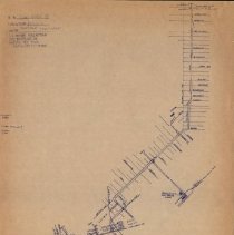
Hand-drawn Texas Electric Railway Trackage Map, Dallas, 1933 |
Date |
1933 |
Scope & Content |
Copy of hand-drawn trackage map of Dallas, 1933. This map was drawn by Johnny J. Myers in 1950. Of note, thought the map title indicates 1933, information in the top left corner of the map indicates it represents trackage for the period 1925-1948. The north end of the map stops at Mockingbird Lane, while the south end of the map stops at the Monroe Shops. The map notes Detail A, B and C, which represent magnified inserts found on Map 8 of the map set created for the book 'Texas Electric Railway', by Johnnie J. Myers. Key locations noted on the map include: * Dallas Railway & Terminal East Dallas Shops * Dallas Railway & Terminal Oak Cliff Shops (near Monroe Shops) * Houston & Texas Central Railroad * Interurban Station (Detail A; Detail C on map 8) * Freight Depot Detail (Detail B) * Texas Electric Railway Freight Yard (Detail C; Detail A on map 8 and known as Monroe Shops) * Union Station * Ball Park [Burnett Field] |
Associated People |
Myers, Johnnie J. |
Search Terms |
Burnett Field Dallas County Dallas Freight Terminal Dallas Interurban Terminal Dallas Railway and Terminal Company Dallas Railway and Terminal Company Shops Houston and Texas Central Railroad Icon-Other TER Maps Map Map 3 Map 8 Map 8 Detail A Map 8 Detail B Map 8 Detail C Monroe Shops Trackage Union Station |
Collection |
Johnnie J. Myers Collection |
Catalog Number |
CP.2006.CL.1-168 |