
Archive Record
Images
Metadata
Object Name |
Map |
Title |
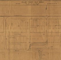
Dallas County Plat Book Map, Blocks 78 to 79 |
Scope & Content |
Dallas County Plat Book Map of the City of Dallas, Blocks 78 to 79. This map shows the area around the Dallas Interurban Terminal, bounded by Akard (west), Commerce (north), Ervay (east) and Wood (south) Streets. Buildings identified as part of the drawing are: * Baker Hotel * Southland Life Building * Dallas Power & Light Co. Building * Southwestern Belll Telephone Building * Interurban Building Interurban tracks on the boundary streets, as well as tracks beside the Interurban Terminal and into the overflow area have been handdrawn onto the map. The pit and the Trainmen's Quarters have also been handdrawn onto the map. See: Map 8, Detail C |
Search Terms |
Akard Street - Dallas Browder Street - Dallas Commerce Street - Dallas Dallas Interurban Terminal Dallas Interurban Terminal Pit Dallas Interurban Terminal Rear Yards Dallas Interurban Terminal Storage Yard Ervay Street - Dallas Icon-Other TER Maps Lane Street - Dallas Map Map 8 Detail C Trainmens Quarters |
Collection |
Johnnie J. Myers Collection |
Catalog Number |
CP.2006.CL.1-144 |