Search Term Record
Metadata
Search Term |
Collin County |
Number of Archive records in Research Center |
46 |
Number of Photo records in Research Center |
679 |
Number of Library records in Research Center |
3 |
Number of Object records in Research Center |
1 |
Related Records
-
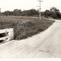
Aldredge Stop South of Plano - ca 1917
View of grade crossing at Aldredge Stop, south of Richardson. A former Dallas Southern Traction Company car is moving into the photo from the mid-left side of the photo. Note to the right of the road, as it curves to the left, is a crossing sign that appears to be in need of repair. See: Map 3, Detail 23
Record Type: Photo
-
-
![TER Finance Docket 16092 [pg 1]](https://s3.amazonaws.com/pastperfectonline/images/museum_1030/014/thumbs/cp2006cl1108 a.jpg)
-
-
-
-
Car Barn Siding - VA Hospital Stop in McKinney - 1948, December 19
SNAPSHOT: Texas Electric Railway "Car Barn" Siding and VA Hospital Stop north of McKinney; view looking south. The structure in the upper right quadrant of the photo is the McKinney powerhouse. See: Map 2, Detail 15; Detail Car Barn Siding
Record Type: Photo

-
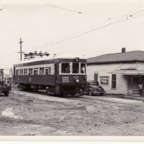
CERA Fan Trip on Passenger Motor 365 at Anna - 1948, July 4
Texas Electric Railway Company Passenger Motor 365 at the Anna Station, which stands out of sight to the left of the truck. The photo was taken at the corner of West 4th Street and (what is now) South Interurban Street. The view is looking towards the southwest. Passenger Motor 365 had been chartered by CERA fans making a final journey before the line was abandoned at the end of 1948. See: Map 2, Detail 10
Record Type: Photo
-
![Car 360 Move Planning Document [Before Move]](https://s3.amazonaws.com/pastperfectonline/images/museum_1030/014/thumbs/cp2006cl1110.jpg)
-
![Car 360 Move Planning Document [Day of Move] Attachment](https://s3.amazonaws.com/pastperfectonline/images/museum_1030/014/thumbs/cp2006cl11101.jpg)
-
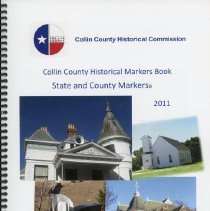
Collin County Historical markers book: State and county markers, 2011 - Collin County Historical Commission
Record Type: Library
-
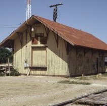
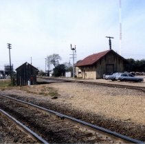
Cotton Belt Depot - ca 1983
This photo of the Cotton Belt Depot is looking south. St. Louis-Southwestern Railway (SSW), is commonly referred to as the Cotton Belt Railroad. The track to the left is Cotton Belt interchange track with Southern Pacific Railroad. The depot was torn down about 1988.
Record Type: Photo
-
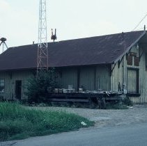
Cotton Belt Depot - ca 1983
This photo of the Cotton Belt Depot is looking southeast. St. Louis-Southwestern Railway (SSW), is commonly referred to as the Cotton Belt Railroad. The track to the left is Cotton Belt interchange track with Southern Pacific Railroad. The depot was torn down about 1988.
Record Type: Photo
-
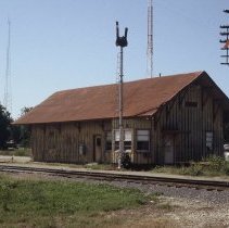
Cotton Belt Depot - ca 1983
This photo of the Cotton Belt Depot is looking northwest. St. Louis-Southwestern Railway (SSW), is commonly referred to as the Cotton Belt Railroad. The track to the left is Cotton Belt interchange track with Southern Pacific Railroad. The depot was torn down about 1988.
Record Type: Photo
-
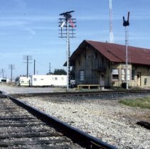
Cotton Belt Depot - ca 1986- Nov 1988
SNAPSHOT: This photo is looking west with the Cotton Belt Depot on the right. St. Louis-Southwestern Railway (SSW), is commonly referred to as the Cotton Belt Railroad. The depot was torn down about 1988. The St. Louis-Southwestern Railway (reporting mark SSW), known by its nickname of "The Cotton Belt Route" or simply Cotton Belt, is a former US Class I railroad which operated between St. Louis, Missouri, and various points in the states of...
Record Type: Photo
-
Cotton Belt Depot - ca 1986-Nov 1988
SNAPSHOT: This photo is looking east with the Cotton Belt Depot on the right. St. Louis-Southwestern Railway (SSW), is commonly referred to as the Cotton Belt Railroad. The track to the left is Cotton Belt interchange track with Southern Pacific Railroad. The depot was torn down about 1988.
Record Type: Photo
-
Cotton Belt Depot at Night - ca 1983
This night time photo of the Cotton Belt Depot is looking south. St. Louis-Southwestern Railway (SSW), is commonly referred to as the Cotton Belt Railroad. The track to the left is Cotton Belt interchange track with Southern Pacific Railroad. The depot was torn down about 1988.
Record Type: Photo

-
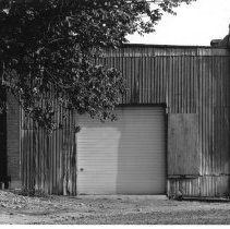
Deteriorated Exterior of Plano Depot - East Elevation - ca 1983
The north end of the deteriorated exterior of the Plano depot and substation east elevation. For more information about the restoration of Plano Station, see our blog at: https://interurbanrailwaymuseum.wordpress.com/2020/11/17/plano-substation-part-ii-the-restoration/
Record Type: Photo
-
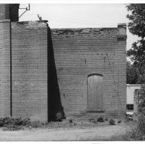
Deteriorated Exterior of Plano Depot - East Elevation - ca 1983
With the machinery long removed for it's salvage value, the deteriorated exterior of the Plano depot and substation appears stark and bleak. View is from the east. The old Plano station ticket office is the wooden structure to the left; the old brick substation rises to the right. A blank sign sits atop the pole immediately to the left of the old station ticket office. On the north side of the tower were "arched windows" that permitted hi...
Record Type: Photo
-
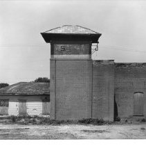
Deteriorated Exterior of Plano Depot - North Elevation - ca 1983
With the machinery long removed for salvage, the deteriorated exterior of the Plano substation appears stark and bleak. This view is looking from the north. The freight dock, which sat just north of the station, and freight station office and storage attached to the substation were gone by this time. For more information about the restoration of Plano Station, see our blog at: https://interurbanrailwaymuseum.wordpress.com/2020/11/17/plano-...
Record Type: Photo